The U.S. Forest Service says more than 1.2 million acres have burned this year in the Northwest due to wildfires. Estimated cost of fighting the fires exceeded $673 million. (Forest Service NW Photo via Twitter)
The skiing could get worse, too. But on the bright side, warm-weather grape varieties may produce better Northwest wine for drowning our sorrows.
Those are just some of the projections contained in the latest edition of the National Climate Assessment, an encyclopedic rundown of the expected region-by-region impacts of climate change on the United States.
A color-coded map shows how smoke is expected to be distributed across Western Washington on the morning of Aug. 23. (NWS Seattle via Twitter)
After enduring days of record-setting, eye-watering levels of smoke in the air, the Seattle area is in for relief, thanks to a shift in wind patterns. But the debate over whether this is the “new normal,” the old normal or the abnormal is likely to play out for months and years to come.
A color-coded image based on NASA’s GEOS-5 satellite data model shows concentrations of black carbon in the atmosphere over North America on Aug. 15. (NASA Image)
The smoky skies over Seattle have cleared up somewhat, but the Pacific Northwest’s wildfires continue to burn — prompting pledges from Republicans as well as Democrats to beef up the region’s firefighting capabilities.
Advanced firefighting technologies, including satellite monitoring, drone patrols and risk management tools based on big data, received loud shout-outs today during a Capitol Hill news briefing.
“That’s the wave of the future,” Sen. Ron Wyden, D-Ore., said.
Agriculture Secretary Sonny Perdue said the Trump administration would step up its coordination efforts with local and state authorities to prevent wildfires and to fight them once they start. “Frankly, we cannot do this ourselves,” Perdue said.
A hazy day dawns over the Seattle skyline, as seen from the Space Needle. (Space Needle Panocam)
If this week’s smoky skies seem unprecedented, that’s not far wrong: Thanks to an unusually unfortunate weather pattern, Seattle just recorded its worst 24-hour air quality in almost two decades of recordkeeping.
University of Washington atmospheric scientist Cliff Mass called attention to the high levels in a blog post today. “I have been here a long time, and I have never seen anything this bad,” Mass wrote.
How bad is it? Mass said particulate readings from the Puget Sound Clean Air Agency’s Duwamish monitoring site have registered the worst 24-hour average air quality since the agency began keeping records in 2000.
An extreme ultraviolet image of the sun, captured by NASA’s Solar Dynamics Observatory, shows an X9.3 flare erupting at lower right. (NASA / Goddard / SDO Photo)
The sun has been acting up this week, and normally that would produce auroral displays bright enough to see in Washington state.
But this isn’t a normal week: Western skies have been obscured by wildfire smoke, and although westerly winds are expected to push out a lot of that smoke overnight in the Seattle area, it’s debatable whether northern lights will be visible.
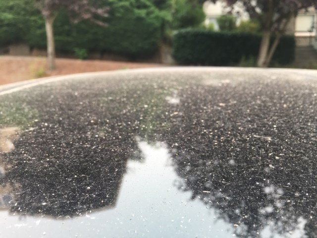
Car roofs are being peppered with ash from Washington’s wildfires. (GeekWire Photo / Todd Bishop)
Texas has its floods, Florida has a potentially catastrophic hurricane coming its way, but the Pacific Northwest has its own sign of the apocalypse: wildfires that are turning the sun into a smoke-obscured blood orange and peppering the streets with ash.
“I have been forecasting around here for a long time and have never seen a situation like this,” Cliff Mass, a University of Washington professor of atmospheric sciences, wrote on his blog this morning.
KCPQ meteorologist Rebecca Stevenson suggested that Seattleites should sweep up the ash and put it in baggies “to save and mark the incredibly hot/dry summer of 2017.”
Weather conditions have been conducive to wildfires all summer long, even in the stereotypically rainy Northwest. Western Washington suffered through smoky skies last month, due primarily to fires in British Columbia, but this week is shaping up as even worse.
Insitu’s winged ScanEagle drone is prepared for launch during a wildfire. (Insitu Photo)
There’s new cause for hope in the fight against wildfires, and it involves Insitu, a Boeing subsidiary that’s headquartered in Bingen, Wash., and specializes in unmanned aerial vehicles.
Today Insitu announced a partnership with FireWhat, a California-based company that focuses on monitoring natural resources with Geographic Information Systems; and Esri, the global market leader in GIS software.
The three companies will use Insitu’s ScanEagle drones, FireWhat’s fire-monitoring technology and Esri’s ArcGIS platform to provide near-real time, web-based video feeds to mobile command centers.
During the day, military-grade electro-optical cameras will help fire incident commanders monitor the battle against wildfires. During the night, infrared cameras will keep watch. The aerial reconnaissance system will make use of an integrated imaging system developed by Insitu’s INEXA Solutions.
A color-coded image from the Landsat 8 satellite’s Operational Land Imager shows fire and smoke in the vicinity of Fort McMurray in Alberta, Canada. The red spots indicate active fires. Smoke appears white, and burned areas appear brown. The image was acquired May 5. (Credit: NASA / USGS)FireFiW
Canadian firefighters are still struggling to get a handle on wide-ranging wildfires in Alberta’s oil-sand country, and satellite images are helping them see the big picture.
Among the space assets tracking the conflagration around Fort McMurray are Landsat 8 and the Suomi NPP satellites. Those spacecraft and their images are jointly managed by NASA and other agencies, including the U.S. Geological Survey, the National Oceanic and Atmospheric Administration and the Defense Department.
Landsat provides pictures in infrared as well as visible wavelengths, which makes it easy to identify hotspots and help planners on the ground identify the worst fires. Suomi NPP bristles with Earth-observing instruments, including radiometers and spectral imagers that can track fire, smoke and weather systems day and night.
The satellite readings give emergency response agencies a wide-angle view on the crisis in Alberta, which already has forced more than 80,000 people to flee Fort McMurray. The area has been a center for efforts to extract petroleum from the Athabasca oil sands, so much so that Fort McMurray picked up the nickname “Fort McMoney.” It’s a big reason why Canada ranks No. 3 in proven oil reserves (after Saudi Arabia and Venezuela) – and why crude oil prices rose this week.